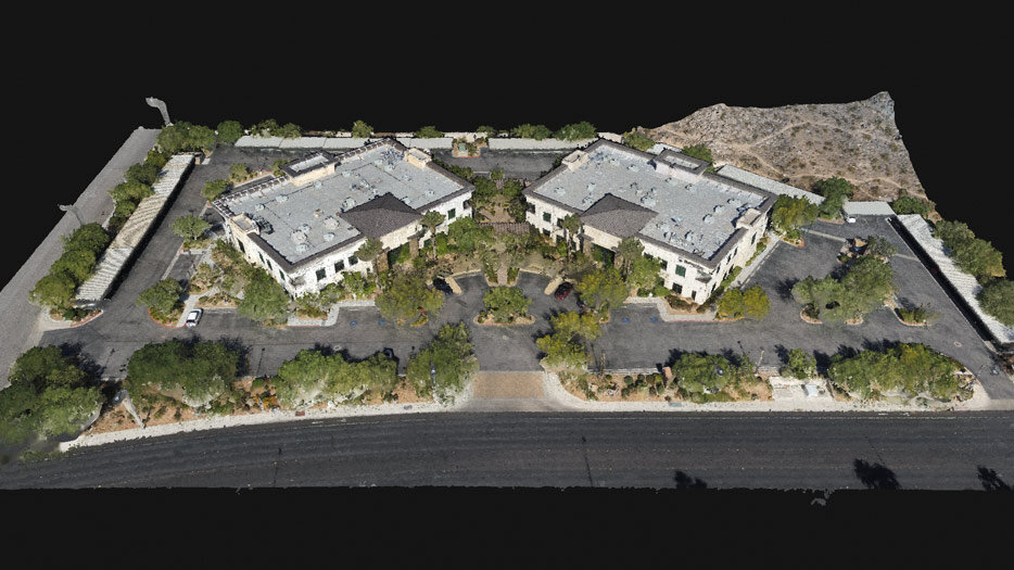
As the uses for drones are becoming more commonly wide-spread, one of the most exciting applications of this technology is aerial surveying. Also referred to as ‘Drone Mapping’; simply put, this practice involves acquiring hundreds of aerial images and then ‘stitching’ them together digitally with specialized mapping software to make a larger more accurate composite image. In this article, we’ll be talking about what drone mapping is used for, and how your business might be able to take advantage of it.
WHAT IS DRONE MAPPING?
Before we dive into what drone mapping is used for, let’s first make sure we have a foundational understanding of the practice itself, which is called photogrammetry. According to photogrammetry.com, “photogrammetry is the science of making measurements from photographs”. The input to photogrammetry is [aerial] photographs, and the resulting output is typically a map, a rendering, a measurement, or a 3D model of some real-world object or scene, and is often used in fields such as topographic mapping, architecture, engineering, manufacturing, quality control, and police investigation, just to name a few.
In order to create a digital representation of reality, data collection of the subject must first occur. Typically this is accomplished with a drone or sUAV, flying a predetermined grid-like flight plan over the subject property capturing hundreds of nadir (straight down) or oblique (30–45-degree angle) photographs.
For the short and sweet answer to “What is Photogrammetry?”, we answered it in under 100 words.
Once acquired, these images need to be analyzed and processed for commonalities in order to create what is called a ‘Point Cloud’. There are several photogrammetry software applications available, with two of the industry leaders being DroneDeploy and our favorite, Pix4D. It is this software that will ultimately create a digital representation of reality by stitching together the hundreds of images captured during a mapping mission flight.
TYPES OF MAPS
You’ll need to know what type of map you’ll be creating during post-processing, as it will determine the type of flight required for that desired output. But without getting into the nitty-gritty, here we’ll explain a few of the most requested outputs available and the benefits they provide.
Orthomosaic Map
An orthomosaic map (or ortho-map) is a composite image looking straight down, generally created for large areas of property. These maps can be used for taking accurate distance and surface-area measurements as the distortion at the edges of the images due to the curvature of the earth have been accounted for and corrected in the software. This creates a perfectly straight-down view over all portions of the image without any change in view based on perspective.
DSM & DTM (Digital Surface Model and Digital Terrain Model)
A Digital Surface Model is a digital representation of the earth’s surface within a set of predefined coordinates, and all objects elevated above the ground like trees and buildings. Unlike the DSM, a Digital Terrain Model (or DTM) does not include any structures or objects and only represents the surface of the earth. Both utilize RGB data to represent differences in elevation, as illustrated in the following image.
Contour Line Maps
Often simply referred to as ‘Contours’ or ‘Topographic Maps’ are two-dimensional maps, where the lines on the map join points of equal elevation. These lines reveal peaks and valleys as well as the steepness of the slope.
Contour lines generally come in three varieties on any given map, and they Index Lines, Intermediate Lines, and Supplementary Lines. Index lines are the thickest lines on the map and are most often labeled with a number stating the elevation above MSL (Mean Sea Level). Intermediate Lines are thinner and found in an interval of five for every one Index Line, representing a variation in elevation loss or gain. Supplementary Lines appear as dotted and depict flatter more level terrain.
We only touched on a few of the most requested types of maps, but there are several other types that can be created such as 3D maps, or Reflectance, Index, and Thermal maps to name a few others. These three are often utilized in what is referred to as precision agriculture.
SO WHAT IS DRONE MAPPING USED FOR?
Just about anything that you could stand to have a better look at or view of. Drone surveying and mapping literally give you the ability to “see the big picture” — but perhaps the most important single thing a drone is used for is to ‘save time’. Whether surveying a section of undeveloped land for future development, creating an ortho-map of a 100-acre ranch to better manage cattle grazing, building 3D models for real estate marketing, or infrastructure inspection and management — the uses are far and wide-reaching and we can capture data in a fraction of the time.
A map itself is valuable, but when you can merge real-world map data with industry-standard software like CAD, the possibilities are limitless. Builders are monitoring construction site progress in near real-time, and able to do on-the-spot ‘as-built’ vs. ‘as-designed’ assessments.
If you’re not sure how you might implement this technology into your existing operation but want to learn more, then reach out to us and we’d be happy to answer any questions you may have.
ProAerial Media provides aerial drone services for all of the industries listed above as well as special events. Subscribe to our YouTube Channel to see our video work, and our Instagram feed to view our photography (@proaerialmedia). If you’re ready to fly, you can always book a flight from the ProAerial Media Website.
Thanks for reading. Take Flight. Take Pics. Get Clicks.


